Saturday, 2 June 2012

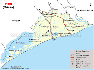
Puri (Oriya: ପୁରୀ ଜିଲ୍ଲା)

It is situated on the Bay of Bengal 60 Kilometers (37 miles) south of the state capital Bhubaneswar in the Indian state of Odisha. It is also known as Jagannath Puri Dham after the 11th century Jagannath Temple located in the city. Puri is a holy city of the Hindus as a part of the Char Dham  pilgrimages. According to Hindu teachings, a pilgrimage of the temples of India is not considered complete without a journey to Puri.Puri is endowed with one of the best beaches for swimming in India and is therefore also a popular beach resort, especially as it is positioned geographically so that both sunset and sunrise can be viewed from the beach.

Puri, the holy land of Lord Jagannath, has many names. It is mentioned in Puranas as Srikshetra, Shankhakshetra, Neelāchala, Neelādri, Purusottama Dhāma, Purusottama Kshetra, Purusottama Puri and Jagannath Puri. The word "Puri" in Sanskrit means 'town', or 'city' and is cognate with polis in Greek. It is possible that Puri is a shortened name for Jagannath Puri or Purusottama Puri. In some records pertaining to the British rule, the word 'Jagannath' was used for Puri.It is the only shrine in India, where Radha, along with Lakshmi, Durga, Sati, Parvati, and Shakti abodes with Krishna, also known as Jagannath. More...

Rayagada (Oriya:ରାୟଗଡା ଜିଲ୍ଲା)

Rayagada District (ରାୟଗଡା ଜିଲ୍ଲା)
It is such a district where you can find lots of  meadows. Lots of dense forests can be found, huge and nice water falls with terraced valleys and along with that you can find the people of many primitive tribal groups. The scenic beauty and heritage on the land is an unexplored paradise. Total 11 Taluks , 176 Villages are in this District .Rayagada has a great mineral source, with full of bauxite, silicon. According to a survey India has 56% of total bauxite storage of the world out of which Orissa has 62%. Out of that Rayagada has a 84% share. Depending on this, other industries like Birla, L&T, Sterlite showed an interest in Rayagada.

People of Rayagada Tribes
The people that they are living in this district can clearly be seen that how far they are lacking behind from urbanization and civilization. The Scheduled  Tribes that are living in this district posses did similar economics. You can always find them in gathering food from the forest of cultivating the cultivation. Peoples are not very much in-touch with the today's world, and that drags them to wear the skins of different animals to cover their body. The language, societies and cultures are very much different from the general ones.


Travel
Rayagada is nearly 226 KM from Bhubaneswar.


Rayagada is near about 226 KM from Bhubaneswar by Train.


Popular Names
  • Varun Sandesh
  • G.Anil Kumar
  • Mitra Sekhar Dora
  • B.Srikanth
  • K Avinash


Population
Total Population of Rayagada is 823019 .405631 Males , 417388 Females .Rayagada is in 3rd position in the state By Population .


Literacy
Rayagada has an average literacy rate of 64%, higher than the national average of 59.5%: male literacy is 72%, and female literacy is 56%.


For more you can also visit Rayagada District

Sundergarh (Oriya: ସୁନ୍ଦରଗଡ଼)

Sundargarh District
Sundargarh (Oriya: ସୁନ୍ଦରଗଡ଼)
It is a district in Odissa. In this district Rourkela is one of the most important place for all the tourists and business man. The Roulkela Steel Plant is the main business hub for all the business man.


Topography
The Sundargarh district is located at 22°07′N 84°02′E / 22.12°N 84.03°E / 22.12; 84.03. It has an average elevation of 243 meters (801 feet).

History

Sundargarh was the capital of princely State of Gangpur till 1948 and it became the District Headquarter of Sundargarh from 1948. It is understood that, in ancient times, Sundargarh was under the rulers of South Kosala. However, divergent views are available regarding the origin of the ruling family. The present royal family of Gangpur belongs to the Parmar dynasty. This ex-state was under the suzerainty of Sambalpur which formed part of the dominion of the Maratha Raja's of Nagpur. This was ceded to the British Government in 1803 by the Maratha Chief Raghuji Bhonsla of Nagpur under the treaty of Deogaon (near Rourkela). But this was restored to him by special engagement in 1806. This was finally ceded in 1826. In 1905, this princely state along with Bonai was transferred from the control of the commissioner of Chhotanagur to that of Odisha Division and a separate Political Agent was appointed.


Census Report
As of 2001 India census, Sundargarh had a population of 40,943. Males constitute 51% of the population and females 49%. Sundargarh has an average literacy rate of 75%, higher than the national average of 59.5%: male literacy is 80%, and female literacy is 69%. In Sundargarh, 11% of the population is under 6 years of age.Goudas (Yadavs) and Bhuiyans are the two castes that covers most of the population in Sundargarh, since the golden King age.

Sambalpur(Oriya:ସମ୍ବଲପୁର)(Hindi:सम्बलपुर)

Sambalpur District


Sambalpur


This district is in the Western part of state of Odisha, India. The district is located in the basin of River Mahanadi. Previously, Sambalpur used to be known for its importance as a Diamond Trading Center, but now-a-days it's mainly known for it's Textiles, especially the Sambalpuri Saree.


Topography


It has a total area of 6,702 square kilometers, of which almost 60% of the district is covered in dense forest.
The district is bounded by Deogarh District to the east, Bargarh and Jharsuguda districts to the west, Sundergarh District to the North, and Subarnapur and Angul districts in the south. Sambalpur city is the connecting city between Chhattisgarh and Odisha.


Economic Background


The economy of Sambalpur District is basically dependent on agriculture and secondly on forests. Forests play an important role in the economy in terms of contribution to revenue, Domestic Product as well as dependence of people for livelihood. Hand-looms Sector and Handicrafts Sectors are also one more way to get the revenue for the districts.


 To know more about Sambalpur, Click here on More.....

Sonepur or Subarnapur(Oriya: ସୁବର୍ଣ୍ଣପୁର)

Sonepur District
Sonepur District (Oriya: ସୁବର୍ଣ୍ଣପୁର ଜିଲ୍ଲା)
It is also called Sonapur District or Subarnapur District. It is an administrative district of Odisha state in eastern India. The town of Sonepur is the district headquarters. Many local people use to call the people of Sonepur region as Sonepuria. This district earned the name “Subarnapur” during the time of Somavamsi ruler.

History
In 2006 the Ministry of Panchayati Raj named Subarnapur one of the country's 250 most backward districts (out of a total of 640). It is one of the 19 districts in Odisha currently receiving funds from the Backward Regions Grant Fund Programme (BRGF).

Census Report
According to the 2011 census Subarnapur district has a population of 652,107. This gives it a ranking of 512th in India (out of a total of 640).This district has a population density of 279 inhabitants per square kilometre (720 /sq mi). It's population growth rate over the decade 2001-2011 was 20.35 %. Subarnapur has a sex ratio of 959 females for every 1000 males, and a literacy rate of 74.42 %.

About Odisha

This post is all about Odisha

Odisha is a state of India, located on the east coast of India, by the Bay of Bengal. It is the modern name of the ancient nation of Kalinga. April is therefore celebrated as Utkal. Bhubaneswar was officially declared as the new capital of Odisha, replacing Cuttack.
Odisha is the ninth largest state by area in India, and the eleventh largest by population. Oriya is the official and most widely spoken language. Other languages spoken in the state are English, Hindi, Bengali, and Telugu.

Different District Of Odisha
Capital Of Odisha: Bhubaneswar


Angul Cuttack Jajapur (Jajpur) Koraput Nayagarh
Boudh (Bauda) Debagarh Jagatsinghpur Kendrapara Puri
Bolangir (Balangir) Dhenkanal Khordha Malkangiri Rayagada
Bargarh (Baragarh) Ganjam Kendujhar Mayurbhanj Sambalpur
Baleswar(Balasore) Gajapati Kalahandi Nabarangpur Sundargarh
Bhadrak Jharsuguda Kandhamal Nuapada Sonepur


Ganjam District (Oriya: ଗଞ୍ଜାମ ଜିଲ୍ଲା)


It is a commercial district in the state of Odisha. Ganjam district has been blessed with beautiful and mineral reached coast extended over 60 K.M. It provides unique opportunity for fishing and port facility at Gopalpur for international trade. The rivers like Rushikulya, Dhanei, Bahuda, Ghoda Hada are the source of agriculture and power sectors of the district.Gopalpur beach of Odisha is just 16 km from Berhampur.

Ganjam district is named after the Old Township and European fort of Ganjam. The name Ganjam comes from the word Gan-i-aam which means Granary of the World. It is spreading over the geographical area of 8070.60 square km. in Odisha. There are 22 blocks, 475 Grampanchayats, 18 Urban Local bodies, 3229 villages, 29 Police Stations and 13 Assembly Constituencies.


Getting more information visit Ganjam District.

Beaches of Odisha

The beaches of Odisha are very vast stretches with golden sand and pleasent weather. The tourists from inside and abroad gets a wonderful experince and oppertunity to experience the natural beauty of these places. The sea beaches of the state attracts several tourist from near and far away places on a huge numbers to vist these sea beaches on a regular basis.

The waves of Bay of Bengal are very obstreperous and simultenioulsly sea breezes make Odisha beaches the perfect place to hang on and the best to spend some time with the family and friends. Tourist can find many Resorts and Hotels besides these beaches to enjoy there vacations and spend some precious time with their close ones.

To increase more number of tourists to the State, special steps were taken by the State Government of Odisha. There are several sea beaches like (Puri Beaches, Chandipur Beach, Gopalpur Beach, Talasari Beach) in Odisha where a tourist had enough liberty to swim accross the high waves and they can enjoy sunbath on the sandy beaches.

The Puri Festival of Puri is a special attraction for the tourists. The Puri Festival displays the rich cultural heritage and traditional legacy of the state through the brilliant performances of the artists of Odissi Dance and Classical Music.

Far from the maddening crowd and hustle bustle of the city life, the serene and calm surrounding of the beaches of Odisha relieves the tourists from the stress and strains of daily mundane life. The beaches are easily accessible by good roads and well laid railway tracks from all parts of the country.

Below is the list of Odisha Beaches:


History of Odisha


The glory and the history of ancient Odisha spanning from last 2000 Years. It was proud Kingdom of Kalinga. Kalinga was only state that controlled most of the sea routes in Bay of Bengal.
For many centuries, a substantial part of Southeast Asia, such as Kampuchea (Cambodia), Java, Sumatra, Bali and Thailand were colonies of Odisha.

As a fact the name of the country "Siam" is derived from Oriya/Sanskrit Shyamadesha.

The temple of Angkor Wat is a fine example of Odisha's architecture, with some local variations. Bali still retains the heritage of Odisha.

A major turning point in world history took place in Odisha. The famous Kalinga war that led emperor Ashoka to embrace non-violence and the teachings of Buddha was fought here in 261 BC near the Daya River which is often said that the whole river tured out to be red with blood.

Later on, Ashoka did recognized his fault and became a desiple of Gautam Budha. Then at a later stage after getting the whole Gyan from Gautam Budha he started preading Buddhist philosophy all over Asia with his Son() and Daughter ().

In the second century BC, Kalinga flourished as a powerful kingdom under Kharavela. It is he who was built the superb monastic caves at Udayagiri and Khandagiri.Subsequently, the kingdom was ruled under various monarchs, such as Samudragupta and Sasanka. It also was a part of Harsha's empire.

In 795 AD, the king Yayati united Kalinga, Kosala and Utkala into a single empire. He also built the famous Jagannath temple at Puri.

King Languda Narasimha Dev is reputed to have built the magnificent sun temple in Konark. Although now largely in ruins, the temple would easily have rivaled the Taj Mahal in splendor.

The ruins of a major ancient university and center of Buddhist learning, Ratnagiri, was recently discovered in Odisha. Scholars from far away lands, such as Greece, Persia and China used to study philosophy, astronomy, mathematics and science at this famed University.

Taxila, Nalanda and Ratnagiri are the oldest universities in the world. The ruins of Ratnagiri University have not been fully excavated yet.

During the dark ages of Indian civilization, Odisha was ruled by a succession of Muslim kings. It was later annexed by emperor Akbar and became part of the Mughal empire.

After the fall of the Mughals, the Marathas under Shivaji invaded the land and continued to rule until 1803 AD when Odisha fell prey to the barbaric British.

Modern Odisha was carved out of Bihar in 1936. Contemporary Odisha has a proud cultural heritage that arose due to the intermingling of three great religious traditions - Hinduism, Buddhism and Jainism and later on enriched by Islam and Christianity.
Odisha at a Glance


A state which is one of the unique state of India. Orissa is also known as Odisha. It is located in the East Coast of India, by the Bay of Bengal. Previously this state was know as Kalinga which was invaded by one of the Maurya Emperor Ashoka in 261 BC. Orissa as the modern state was established on April 1st 1936 at Kanika Palace, Cuttack, as a province in India, and consists and dominated by Odia speakers. That's why April 1st is therefore celebrated as Utkal Divas (Odisha Day).